The Role of Technology in Disaster Relief Coordination
In today's world, where natural disasters can strike with little warning, the importance of effective disaster relief coordination cannot be overstated. The role of technology in this arena has transformed how agencies and organizations respond to emergencies. Imagine a world where communication flows seamlessly, resources are allocated efficiently, and responders have access to real-time data. This is not just a dream; it's a reality made possible by the advancements in technology.
When disaster strikes, the chaos can be overwhelming. However, technology acts as a lifeline, connecting various stakeholders involved in the relief efforts. From government agencies to non-profit organizations, everyone can benefit from enhanced communication tools that ensure timely updates and information sharing. This level of connectivity is crucial for ensuring that aid reaches those who need it most, and it allows responders to coordinate their efforts effectively.
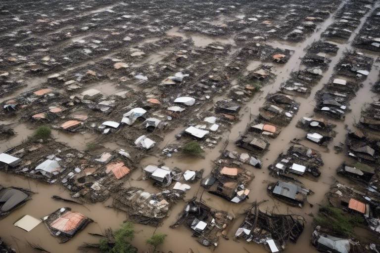
Moreover, technology enables the collection and analysis of vast amounts of data during disasters. This data is invaluable as it helps agencies understand the situation better, predict needs, and allocate resources more effectively. For instance, Geographic Information Systems (GIS) can map affected areas, identify available resources, and plan response strategies. The visual insights provided by GIS enhance situational awareness, allowing responders to prioritize areas that require immediate assistance.
Additionally, remote sensing technology, including satellites and drones, offers critical data on disaster impacts. These tools allow for quick assessments of damage, informing responders about the extent of the disaster and guiding them in planning effective relief operations. Imagine being able to see the damage from above, pinpointing where help is needed most. This capability can significantly enhance the speed and efficiency of disaster response.
As we delve deeper into the role of technology in disaster relief coordination, it's essential to recognize the various mobile applications that have emerged as vital tools. These apps facilitate communication among responders, provide real-time updates, and offer users essential information during emergencies. With just a few taps on a smartphone, responders can access crucial updates and coordinate their actions accordingly, ensuring that no one is left in the dark.
In summary, the integration of technology in disaster relief coordination not only improves communication and resource allocation but also enhances overall effectiveness. As technology continues to evolve, we can expect even greater advancements that will further revolutionize disaster response efforts. The future of disaster relief is bright, and technology is leading the way.
- How does technology improve communication during disasters? Technology facilitates real-time updates and information sharing among responders, victims, and organizations, ensuring everyone is informed and coordinated throughout the relief process.
- What role does GIS play in disaster relief? GIS technology helps in mapping affected areas, identifying resources, and planning response strategies, providing visual insights that enhance situational awareness.
- How can mobile applications assist in disaster response? Mobile apps enable real-time alerts, facilitate communication among responders, and engage community members in reporting issues and requesting assistance.
- What are the challenges of using technology in disaster relief? Challenges include data privacy concerns, technological disparities, and the need for training among responders to effectively utilize these tools.
- What future trends can we expect in disaster relief technology? Emerging technologies such as artificial intelligence and machine learning are set to improve predictive analytics, enhance decision-making, and optimize resource allocation during emergencies.

Improving Communication During Crises
Effective communication is crucial in disaster situations. When chaos reigns and every second counts, having the right channels of communication can be the difference between life and death. Technology plays a pivotal role in enhancing communication during crises, allowing for real-time updates and information sharing among responders, victims, and various organizations. Imagine a scenario where a natural disaster strikes; without technology, vital information could be lost in the noise of confusion. But with the right tools, everyone involved can stay informed and coordinated throughout the relief process.
One of the most significant advancements in communication technology is the use of mobile applications. These apps can send alerts and updates directly to users' smartphones, ensuring that responders are aware of the latest developments. For instance, during a hurricane, an app might notify users about evacuation routes or shelter locations. This immediacy is not just convenient; it's essential. Furthermore, these applications often incorporate features that allow community members to report issues, request assistance, and even offer help. This fosters a collaborative environment where everyone can contribute to disaster relief efforts.
In addition to mobile apps, social media platforms have emerged as powerful tools for crisis communication. During a disaster, social media can rapidly disseminate crucial information, such as safety tips, resource availability, and emergency contact numbers. This kind of information spreads like wildfire, reaching a wide audience in a matter of minutes. Organizations can leverage social media not only to inform but also to engage with the public, encouraging donations and volunteer support. This engagement is vital for successful disaster relief operations, as it builds a community of support around those affected.
However, while technology enhances communication, it also presents challenges. For instance, not everyone has access to the latest devices or reliable internet connections, which can create disparities in information dissemination. Moreover, the sheer volume of information can lead to confusion, making it difficult for individuals to discern what is relevant. Therefore, it is crucial for organizations to develop clear communication strategies that prioritize essential information while ensuring that all community members have access to the tools they need.
In conclusion, the role of technology in improving communication during crises cannot be overstated. By utilizing mobile applications, social media, and other technological tools, responders can ensure that everyone is informed and coordinated. As we continue to advance technologically, it is vital to keep refining these tools and strategies to enhance their effectiveness. After all, in the face of disaster, clear and timely communication can make all the difference.
- How does technology improve communication during disasters?
Technology enhances communication by providing real-time updates, facilitating information sharing, and enabling coordination among responders and affected individuals. - What role do mobile applications play in disaster relief?
Mobile applications allow for immediate alerts, community reporting, and provide essential information to users during emergencies. - Can social media be effective during a disaster?
Yes, social media platforms can rapidly disseminate crucial information and engage the public for support and donations. - What challenges does technology face in disaster communication?
Challenges include disparities in access to technology, information overload, and the need for clear communication strategies.

Data Collection and Analysis
When disaster strikes, the ability to collect and analyze data swiftly can mean the difference between life and death. Technology has opened up new avenues for gathering vast amounts of information during emergencies, allowing agencies to respond with precision and urgency. Imagine a situation where every second counts; having real-time data at your fingertips can help responders understand the evolving landscape of a disaster, predict the needs of affected populations, and allocate resources where they are needed the most. This is not just about numbers; it’s about saving lives and restoring communities.
With the advent of advanced data collection methods, organizations can now tap into various sources of information. For instance, social media platforms, satellite imagery, and IoT devices provide a wealth of real-time data. By leveraging these tools, responders can create a comprehensive picture of the situation on the ground. The analysis of this data can reveal patterns and trends that inform decision-making processes. For example, by analyzing historical disaster data alongside current conditions, agencies can anticipate which areas are likely to require more assistance and which resources will be most effective in addressing those needs.
One of the standout technologies in this realm is Geographic Information Systems (GIS). GIS technology is indispensable for mapping affected areas and planning response strategies. It allows responders to visualize the extent of damage and prioritize assistance effectively. With GIS, organizations can create detailed maps that highlight critical infrastructure, such as hospitals and shelters, and identify the most affected neighborhoods. This visual insight enhances situational awareness and streamlines coordination among various agencies involved in disaster relief.
Mapping affected regions using GIS enables responders to visualize the damage's scope. For example, after a hurricane, GIS can display flooded areas, damaged roads, and inaccessible zones. This information is crucial for planning evacuation routes and determining where to send supplies first. By prioritizing areas based on severity, responders can ensure that aid reaches those who need it most without wasting precious time navigating through less affected regions.
Moreover, GIS assists in identifying available resources and their locations. Imagine a scenario where multiple relief agencies are operating in the same region. Without a clear understanding of who has what, resources might be duplicated or, worse, left unused. GIS technology helps mitigate this issue by providing a centralized platform where agencies can share information about their supplies and capabilities. This ensures that supplies reach those in need promptly and efficiently, enhancing the overall effectiveness of the relief effort.
In addition to GIS, remote sensing technology, including satellites and drones, plays a pivotal role in disaster response. These tools provide critical data on disaster impact, enabling quick assessments of damage. For instance, after an earthquake, drones can quickly survey impacted areas, capturing images that reveal structural damage and assessing the needs of the population. This rapid assessment is invaluable for planning effective relief operations, as it allows agencies to deploy resources where they are most needed without delay.
In summary, the integration of advanced data collection and analysis technologies into disaster relief efforts is not just beneficial; it is essential. By harnessing the power of GIS, remote sensing, and real-time data analysis, agencies can enhance their response strategies, ultimately saving lives and ensuring that communities recover more swiftly from disasters.
- How does technology improve disaster response? Technology enhances communication, data collection, and resource allocation, allowing for more efficient and timely responses during emergencies.
- What role do mobile applications play in disaster relief? Mobile applications facilitate real-time updates and allow community members to report issues, fostering better coordination among responders.
- What are the challenges of using technology in disaster relief? Challenges include data privacy concerns, technological disparities among regions, and the need for training among responders.

Geographic Information Systems (GIS)
Geographic Information Systems, commonly known as GIS, have become a cornerstone in the realm of disaster relief coordination. This innovative technology allows organizations to create, analyze, and visualize spatial data, which is essential during emergencies. Imagine being able to see a map that not only displays the affected regions but also highlights the locations of resources, shelters, and safe routes for responders. This is the power of GIS at work.
One of the primary functions of GIS is its ability to map affected areas. When a disaster strikes, responders need to understand the extent of the damage quickly. GIS technology enables them to visualize the impact through detailed maps that show everything from flooded neighborhoods to damaged infrastructure. This visual representation is crucial for prioritizing areas that need immediate assistance. For instance, if a flood has devastated a community, GIS can help responders identify which neighborhoods are most affected and require urgent aid.
Moreover, GIS plays a significant role in resource allocation. During a disaster, the timely delivery of supplies can mean the difference between life and death. GIS helps responders identify available resources in real-time and their proximity to affected areas. By analyzing this data, organizations can coordinate their efforts more effectively, ensuring that food, water, medical supplies, and other essentials reach those in need without unnecessary delays. A well-coordinated effort, supported by GIS technology, can lead to a more efficient disaster response.
To illustrate the impact of GIS, consider the following table that outlines its key benefits in disaster relief:
| Benefit | Description |
|---|---|
| Enhanced Situational Awareness | Provides real-time mapping of affected areas, helping responders understand the scope of the disaster. |
| Improved Decision-Making | Facilitates informed decisions regarding resource distribution and prioritization of aid. |
| Effective Communication | Allows for better coordination among various agencies and organizations involved in disaster relief. |
In conclusion, the integration of GIS into disaster relief efforts is not just beneficial; it is essential. As we continue to face increasingly complex and frequent disasters, leveraging technology like GIS will be vital in ensuring that our response efforts are as effective and efficient as possible. By visualizing data and mapping out strategies, we can save lives and provide the necessary support to communities in distress.

Mapping Affected Areas
Mapping affected regions using Geographic Information Systems (GIS) is a game-changer in disaster relief operations. Imagine a bird's-eye view of a disaster-stricken area, where every detail is captured and analyzed in real-time. This capability allows responders to visualize the extent of damage, prioritize areas for assistance, and navigate effectively to deliver aid where it is most needed. GIS not only provides a comprehensive overview of the disaster but also highlights critical infrastructure, such as hospitals, shelters, and supply routes, which are vital for effective response.
One of the most significant advantages of using GIS technology in disaster mapping is its ability to integrate various data sources. For instance, satellite imagery can be combined with ground-level reports to create an up-to-date picture of the situation. This integrated approach ensures that responders have access to the most accurate information, enabling them to make informed decisions quickly. Furthermore, GIS can help identify vulnerable populations that may require additional assistance, such as the elderly or those with disabilities, ensuring that no one is left behind.
Moreover, GIS technology allows for the creation of interactive maps that can be shared with various stakeholders, including government agencies, NGOs, and community organizations. These maps can display real-time updates on resource availability, ongoing relief efforts, and areas that still need attention. By fostering collaboration and transparency, GIS enhances the overall efficiency of disaster response efforts. As a result, responders can coordinate their actions more effectively, ensuring that resources are allocated where they are most needed.
In summary, mapping affected areas through GIS technology is not just about creating pretty pictures; it's about saving lives and optimizing relief efforts. By providing a clear and detailed understanding of the disaster landscape, GIS empowers responders to act swiftly and strategically, ultimately leading to better outcomes for affected communities.
- What is GIS technology? GIS stands for Geographic Information Systems, a technology used to capture, analyze, and manage spatial and geographic data.
- How does GIS help in disaster relief? GIS helps in mapping affected areas, identifying resources, and planning response strategies, thus improving coordination and efficiency in disaster response.
- Can GIS be used for real-time updates during a disaster? Yes, GIS can integrate real-time data from various sources to provide up-to-date information on the disaster situation.
- What are some limitations of using GIS in disaster relief? Limitations can include data privacy concerns, the need for technical training, and disparities in technology access across different regions.

Resource Allocation
Effective is the backbone of any successful disaster relief operation. In the chaos following a disaster, the ability to quickly identify and deploy resources can mean the difference between life and death. Using Geographic Information Systems (GIS), responders can pinpoint the locations of available resources, such as food, water, medical supplies, and shelter. This technology enables agencies to visualize not only where resources are located but also how they can be efficiently distributed to the areas most in need.
Imagine a scenario where a hurricane has devastated a coastal town. Emergency services need to assess the damage, determine which areas are most affected, and figure out where to send their limited supplies. With GIS, they can create a detailed map that highlights the hardest-hit neighborhoods, allowing them to prioritize their efforts. This mapping capability is crucial because it helps avoid situations where some areas receive an excess of aid while others are left wanting.
Moreover, GIS can assist in tracking the movement of resources in real-time. For instance, if a truck carrying food supplies is en route to a shelter, responders can monitor its progress and make adjustments if necessary—whether that means rerouting the truck due to road closures or sending additional supplies based on the evolving needs of the community. This level of coordination is essential for ensuring that resources are not only available but also reach those who need them most, as quickly as possible.
In addition to GIS, other technologies, such as mobile applications, can enhance resource allocation efforts. These apps can provide responders with instant updates on resource availability and needs, creating a dynamic system where information flows freely between agencies and community members. For example, if a local hospital runs low on medical supplies, they can quickly alert nearby agencies through a mobile app, prompting immediate action to replenish their stock.
Ultimately, the goal of effective resource allocation is to create a well-coordinated response that maximizes the impact of every donation and effort. By leveraging technology, disaster relief organizations can ensure that their resources are utilized efficiently, ultimately saving lives and aiding in the recovery process.
- What is the role of technology in disaster relief?
Technology enhances communication, data collection, and resource allocation, making disaster response more efficient. - How does GIS help in disaster relief?
GIS provides mapping and spatial analysis capabilities that allow responders to visualize affected areas and plan their response strategies effectively. - What are some challenges faced in disaster relief technology?
Challenges include data privacy concerns, technological disparities, and the need for training among responders. - How can mobile applications improve disaster response?
Mobile apps facilitate real-time communication and updates, allowing responders and community members to stay informed and engaged. - What future technologies are expected to improve disaster relief?
Emerging technologies like artificial intelligence and machine learning will enhance predictive analytics and decision-making in disaster scenarios.

Remote Sensing Technology
Remote sensing technology has revolutionized the way we assess and respond to disasters. By utilizing satellites and drones, this technology provides critical data that can be used to gauge the extent of damage caused by natural disasters such as earthquakes, floods, and hurricanes. Imagine being able to see the impact of a disaster from above, gathering information in real-time without putting responders at risk. This capability not only enhances situational awareness but also allows for quicker decision-making, which is essential during emergencies.
One of the key advantages of remote sensing is its ability to cover large areas quickly. For instance, after a massive earthquake, traditional ground assessments can take days or even weeks to gather comprehensive data. In contrast, satellites can capture images of the affected region almost immediately, providing a bird's-eye view of the damage. This rapid assessment helps agencies prioritize their response efforts and allocate resources more effectively.
Moreover, remote sensing technology enables the monitoring of environmental changes over time. By analyzing data collected before and after a disaster, agencies can identify patterns and trends that can inform future preparedness strategies. For example, if certain areas are repeatedly affected by flooding, this information can lead to proactive measures such as improved drainage systems or community education programs about flood risks.
Additionally, remote sensing can be integrated with Geographic Information Systems (GIS) to create detailed maps that highlight critical information. These maps can include:
- Locations of damaged infrastructure
- Areas in need of immediate assistance
- Safe routes for delivering aid
By visualizing this data, organizations can make informed decisions that enhance the efficiency of their disaster response operations. The collaboration between remote sensing and GIS tools is a game-changer, allowing for a comprehensive understanding of the disaster landscape.
In summary, remote sensing technology is an invaluable asset in disaster relief coordination. It not only provides immediate data that can save lives but also supports long-term planning and preparedness efforts. As technology continues to advance, the potential for remote sensing to improve disaster response will only grow, making it an essential component of modern emergency management.
Q1: What is remote sensing technology?
A1: Remote sensing technology involves the use of satellites and drones to collect data about the Earth's surface from a distance. It is widely used in disaster management to assess damage and inform response strategies.
Q2: How does remote sensing improve disaster response?
A2: By providing real-time data and comprehensive imagery of affected areas, remote sensing allows agencies to quickly assess damage, prioritize response efforts, and allocate resources efficiently.
Q3: Can remote sensing data be integrated with other technologies?
A3: Yes, remote sensing data can be integrated with Geographic Information Systems (GIS) to create detailed maps and visualizations that enhance situational awareness and decision-making during disaster response.
Q4: What are some limitations of remote sensing technology?
A4: Some limitations include the reliance on clear weather conditions for accurate data collection and potential data privacy concerns when monitoring affected populations.

Mobile Applications for Coordination
In today's fast-paced world, mobile applications have become indispensable tools for disaster relief coordination. When a disaster strikes, the ability to communicate and share information quickly can mean the difference between life and death. These applications not only facilitate communication among responders but also empower victims and community members to engage actively in the relief efforts. Imagine a scenario where a hurricane has just devastated a region; the chaos can be overwhelming. However, with the right mobile apps, responders can coordinate their actions in real-time, ensuring that help reaches those in need without delay.
One of the most significant advantages of mobile applications is their capability to provide real-time updates. Through notifications and alerts, these apps keep everyone informed about the latest developments. For instance, if a road becomes impassable due to flooding, responders can receive immediate alerts, allowing them to adjust their routes and strategies accordingly. This level of responsiveness is crucial during emergencies when conditions can change rapidly.
Moreover, mobile applications often include features that promote community engagement. Community members can report issues, request assistance, and even offer help through these platforms. This two-way communication fosters a collaborative environment, where everyone plays a role in the relief effort. For example, if someone spots a family in need of food or shelter, they can quickly use the app to notify the relevant authorities, ensuring that help is dispatched promptly. Such engagement not only streamlines the relief process but also builds a sense of community resilience.
To further illustrate the impact of mobile applications in disaster coordination, consider the following table that outlines key features commonly found in these apps:
| Feature | Description |
|---|---|
| Real-Time Alerts | Instant notifications about emergencies, road conditions, and resource availability. |
| Resource Mapping | Visual representation of available resources and their locations for efficient allocation. |
| Community Reporting | Allows users to report issues and request assistance directly through the app. |
| Volunteer Coordination | Connects volunteers with opportunities to assist in relief efforts. |
As we look to the future, the integration of advanced technologies into mobile applications will only enhance their capabilities. Features such as location tracking and artificial intelligence can provide even more personalized and efficient responses to disasters. It's exciting to think about how these tools will evolve, making disaster response not just a coordinated effort, but a community-driven initiative where everyone is informed and involved.
Q1: How do mobile applications improve disaster response?
A1: Mobile applications improve disaster response by facilitating real-time communication, providing updates, and allowing community members to report needs and offer assistance.
Q2: Can anyone use these mobile applications during a disaster?
A2: Yes, many mobile applications are designed for public use, enabling anyone in the affected area to access information and communicate with responders.
Q3: What features should I look for in a disaster relief app?
A3: Look for features such as real-time alerts, resource mapping, community reporting, and volunteer coordination to ensure effective communication and coordination during a disaster.
Q4: Are there any challenges associated with using mobile apps in disaster response?
A4: Yes, challenges include ensuring widespread access to technology, addressing data privacy concerns, and providing adequate training for users.

Real-Time Updates
In the chaotic aftermath of a disaster, can be the difference between life and death. Mobile applications have revolutionized the way information is disseminated, ensuring that responders, volunteers, and affected individuals remain connected and informed. Imagine a scenario where a flood has just hit a community. Without timely information, rescue operations could be delayed, leading to unnecessary suffering. However, with mobile apps, alerts can be sent out instantly, providing critical updates on safety zones, available resources, and emergency contact numbers.
These apps are designed to push notifications directly to users' devices, making it easier for everyone involved to stay on the same page. For instance, if a shelter reaches full capacity, a quick update through the app can inform volunteers and rescue teams to redirect those in need to another location. This real-time communication not only streamlines operations but also builds trust within the community, as individuals feel more secure knowing they have access to the latest information.
Moreover, the capability for users to send updates back through the app enhances the flow of information. Community members can report their current status, request assistance, or even offer help to others. This two-way communication fosters a sense of collaboration and empowers individuals to take an active role in their own recovery. To illustrate, consider how a community-driven update system can efficiently gather data on areas that are still cut off from aid, allowing agencies to prioritize their response efforts effectively.
In summary, the integration of real-time updates through mobile applications not only enhances coordination among disaster relief agencies but also engages the community in the recovery process. As technology continues to evolve, the potential for more sophisticated and user-friendly applications will only increase, making disaster response more efficient and effective.
- How do mobile applications improve disaster response? Mobile applications provide real-time updates, facilitate communication among responders, and allow community members to report issues or request assistance.
- What types of information can be shared through these apps? Information can include safety alerts, resource availability, shelter locations, and updates on ongoing rescue efforts.
- Are there challenges associated with using mobile apps in disaster situations? Yes, challenges include ensuring access to technology for all community members and addressing data privacy concerns.
- How can community members participate in disaster relief efforts through mobile apps? Community members can report their needs, offer assistance, and stay informed about the latest updates and available resources.

Community Engagement
In the realm of disaster relief, is not just a buzzword; it’s a lifeline. When disaster strikes, the immediate response often hinges on how well communities can mobilize and support one another. Mobile applications have revolutionized this aspect of engagement by providing platforms where community members can actively participate in the relief efforts. Through these apps, individuals can report local issues, request assistance, and even offer help to their neighbors. Imagine a neighborhood coming together, each person equipped with the tools to communicate their needs and resources effectively. This kind of collaboration can significantly enhance the speed and efficiency of relief operations.
Moreover, these applications often feature user-friendly interfaces that encourage participation from a wide demographic, ensuring that everyone, from tech-savvy youth to older adults, can contribute. By utilizing features such as geolocation, users can pinpoint their exact location when reporting an emergency or offering assistance. This not only streamlines the process but also ensures that aid reaches those who need it most, in the quickest time possible.
Furthermore, community engagement through mobile apps fosters a sense of ownership and responsibility among residents. When people feel empowered to take action, they are more likely to participate actively in the recovery process. For instance, during a recent natural disaster, a community in a flood-prone area used a mobile app to coordinate sandbagging efforts. Residents could sign up for shifts, share updates on water levels, and communicate with local authorities. This level of organization not only helped mitigate damage but also strengthened community bonds.
To illustrate the impact of community engagement, consider the following table showcasing key benefits:
| Benefit | Description |
|---|---|
| Faster Response Times | Real-time communication allows for quicker mobilization of resources and assistance. |
| Increased Awareness | Community members stay informed about ongoing relief efforts and available resources. |
| Enhanced Collaboration | Encourages partnerships between community members, local organizations, and responders. |
| Empowerment | Residents feel more in control of their circumstances and contribute actively to solutions. |
In conclusion, the role of community engagement in disaster relief cannot be overstated. It transforms passive recipients of aid into active participants in their recovery. By leveraging technology, communities can harness their collective strength, making them more resilient and capable of facing future challenges. As we continue to innovate and improve our disaster response strategies, fostering community engagement will be paramount in creating a safer, more connected world.
- How can technology improve community engagement during disasters?
Technology provides platforms for communication and coordination, allowing community members to report issues, request help, and offer assistance effectively. - What role do mobile applications play in disaster relief?
Mobile apps facilitate real-time updates, enhance communication among responders, and empower community members to engage actively in relief efforts. - Why is community engagement important in disaster response?
Engaged communities can mobilize quickly, share resources, and support each other, leading to faster and more effective disaster response.

Social Media in Disaster Response
In today's digital age, social media has become a powerhouse for communication, especially during disasters. It serves as a vital tool for organizations and individuals alike, enabling rapid information dissemination and fostering community engagement. Imagine a world where help can be summoned with just a tweet or a Facebook post—this is the reality we live in now. Social media platforms like Twitter, Facebook, and Instagram are not just for sharing personal moments; they have transformed into lifelines during emergencies.
One of the most significant advantages of using social media during disasters is the speed at which information can be shared. In a crisis, every second counts, and the ability to quickly spread crucial updates can make a world of difference. For instance, organizations can use these platforms to broadcast safety tips, resource availability, and emergency contact information. This rapid dissemination of information can reach a wide audience, ensuring that affected individuals stay informed about the latest developments. Consider the aftermath of natural disasters like hurricanes or earthquakes; social media can provide real-time updates on evacuation routes, shelter locations, and safety protocols.
Moreover, social media enables public engagement in disaster response efforts. Organizations can interact with the community, encouraging donations and volunteer support, which are essential for successful relief operations. During disasters, many people want to help but may not know how. Social media platforms serve as a bridge, connecting those in need with those willing to assist. For example, a simple post can mobilize a community to gather supplies or volunteer at local shelters. This collaborative spirit not only enhances the effectiveness of disaster response but also fosters a sense of unity among community members.
However, it’s important to note that social media is not without its challenges. The rapid spread of information can sometimes lead to the dissemination of false information or panic-inducing rumors. Therefore, organizations must ensure that their communications are clear, accurate, and timely. Establishing official channels for updates and clarifications can help mitigate this issue. Additionally, monitoring social media can provide valuable insights into public sentiment and needs, allowing organizations to adjust their strategies accordingly.
To summarize, social media has revolutionized disaster response by enabling quick communication, fostering community engagement, and providing a platform for organizations to share vital information. As we continue to navigate the complexities of disaster management, harnessing the power of social media will be crucial in building resilient communities and ensuring effective responses to emergencies.
- How can social media help during a disaster? Social media allows for rapid information sharing, public engagement, and real-time updates, making it an essential tool for disaster response.
- What are the risks of using social media in emergencies? The main risks include the spread of misinformation and the potential for panic among the public. It's important for organizations to provide accurate information and monitor social media activity.
- Can individuals use social media to assist in disaster relief? Absolutely! Individuals can share information, volunteer their time, and donate resources through social media platforms to aid in disaster relief efforts.

Information Dissemination
In the chaotic aftermath of a disaster, the rapid dissemination of information is not just important—it can be the difference between life and death. Social media platforms have emerged as powerful tools for spreading crucial updates and safety information to affected communities. Imagine being in a situation where every second counts; social media acts like a lifeline, connecting people with the information they desperately need. Whether it’s updates about evacuation routes, shelter locations, or emergency contact numbers, these platforms serve as a real-time information hub.
One of the most remarkable aspects of social media is its ability to reach a vast audience almost instantaneously. For instance, a single tweet or Facebook post can inform thousands, if not millions, of individuals about critical safety measures. This rapid information flow ensures that people are not left in the dark, allowing them to make informed decisions about their safety and well-being. Furthermore, social media can also serve to debunk rumors and misinformation that often proliferate during crises, providing a reliable source of truth amidst the chaos.
Additionally, organizations can utilize social media to engage directly with the public. This two-way communication allows agencies to gather real-time feedback from the community, which can be invaluable in understanding the evolving needs of those affected. For example, if someone tweets about a flooded road or a shortage of supplies, agencies can respond quickly, directing resources where they are needed most. This level of engagement fosters a sense of community and collaboration, empowering individuals to play an active role in their own recovery.
To illustrate the impact of social media on information dissemination during disasters, consider the following key points:
- Timeliness: Information can be shared in real-time, ensuring that updates reach those in need without delay.
- Widespread Reach: Social media can connect with diverse populations, transcending geographical barriers.
- Community Involvement: Individuals can report issues and offer assistance, creating a network of support.
In conclusion, the role of social media in disaster response cannot be overstated. It enhances communication, fosters community involvement, and ensures that vital information reaches those who need it most. As we continue to navigate the complexities of disaster management, leveraging these platforms will undoubtedly play a crucial role in improving outcomes and saving lives.
- How does social media improve disaster response?
Social media allows for rapid information sharing, enabling organizations to communicate effectively with the public and coordinate relief efforts. - What are the risks associated with using social media during disasters?
While social media is a powerful tool, it can also spread misinformation. It's essential for organizations to monitor and correct false information promptly. - Can anyone use social media to report issues during a disaster?
Yes! Social media platforms allow individuals to share their experiences and report problems, which can help agencies respond more effectively.

Public Engagement and Support
In today's world, where information travels faster than a lightning bolt, social media has become a game changer for disaster relief efforts. It's not just about organizations stepping in to help; it’s about the entire community coming together to support one another. Imagine a platform where someone can instantly report a flooded street, request food, or even offer a helping hand to those in need. This is the power of public engagement through social media during disasters.
Social media platforms like Twitter, Facebook, and Instagram allow individuals to share their experiences and needs in real time. This rapid dissemination of information helps organizations gauge the public's sentiments and needs, allowing them to tailor their responses accordingly. For example, if a particular area is hit hard by a disaster, social media can highlight those urgent needs, prompting quicker action from relief agencies.
Moreover, public engagement through these platforms encourages community involvement, which is crucial during emergencies. People can easily share information about donation drives, volunteer opportunities, and local resources that are available. This not only fosters a sense of community but also amplifies the impact of relief efforts. Consider this: a single post about a local food drive can reach thousands of people, rallying them to contribute and support their neighbors.
Furthermore, organizations can use social media to mobilize support and resources. They can run campaigns encouraging donations or volunteer sign-ups, creating a ripple effect of goodwill. The transparency of these platforms also allows the public to see where their contributions are going, which can significantly boost trust and engagement. It’s like having a direct line to the heart of the community, where every voice matters and every action counts.
However, engaging the public also comes with its challenges. Misinformation can spread just as quickly as helpful information, leading to confusion and panic. Organizations must be vigilant in monitoring social media channels to correct false narratives and provide accurate updates. This is where the role of social media managers becomes crucial, as they need to ensure that the information shared is not only timely but also factual.
In summary, public engagement and support through social media are invaluable during disaster relief efforts. By harnessing the collective power of the community, organizations can enhance their response strategies, ensuring that aid reaches those who need it most. It's a collaborative effort that transforms the chaos of a disaster into a symphony of support and resilience.
- How can I help during a disaster? You can help by volunteering, donating supplies, or spreading awareness through social media.
- What should I do if I see misinformation on social media? Report it and share accurate information to help clarify the situation.
- How do organizations use social media for disaster relief? They use it to communicate needs, mobilize resources, and engage with the community for support.

Challenges of Technology in Disaster Relief
While technology has undoubtedly transformed disaster relief efforts, it is not without its challenges. One of the most pressing issues is data privacy concerns. During emergencies, vast amounts of sensitive information are collected, including personal details of victims and responders. The risk of exposing this data can lead to a breach of trust among affected populations. Organizations must navigate the fine line between utilizing data for effective response and protecting individual privacy rights. This necessitates stringent data management practices and transparent communication with the public to maintain confidence.
Another significant challenge is the technological disparities that exist between different regions. Not all communities have equal access to advanced technology or the internet, which can create barriers to effective disaster response. For instance, rural or impoverished areas may struggle to utilize mobile applications or GIS tools that are essential for coordination. This gap can lead to unequal assistance, where some communities receive timely aid while others remain in the dark. Addressing these disparities is crucial to ensure that technology serves as a bridge rather than a barrier in disaster relief efforts.
Moreover, there is a critical need for training among responders to effectively utilize these technological tools. While many responders may be familiar with basic technology, the rapid evolution of tools like AI and GIS means that ongoing education is essential. Without proper training, even the best technology can fall short of its potential. Organizations must invest in comprehensive training programs that equip responders with the necessary skills to leverage technology effectively during crises.
In summary, while technology enhances disaster relief coordination, it also presents challenges that must be addressed. From data privacy to technological disparities and the need for training, these hurdles require careful consideration and strategic planning. By acknowledging and tackling these challenges, organizations can ensure that technology serves as a powerful ally in their disaster response efforts.
- What are the main challenges of using technology in disaster relief?
Data privacy concerns, technological disparities, and the need for training among responders are the primary challenges. - How can organizations address data privacy issues during disasters?
Implementing stringent data management practices and maintaining transparent communication with affected populations can help mitigate privacy concerns. - Why is training important for responders using technology?
Training ensures that responders can effectively utilize advanced technological tools, maximizing their potential during emergencies. - What role does technology play in improving disaster response?
Technology enhances communication, data collection, and resource allocation, leading to more efficient and effective disaster relief efforts.

Data Privacy Concerns
In the realm of disaster relief, the use of technology has been a game changer, but it also brings with it a host of that cannot be overlooked. When agencies collect and share information during emergencies, they often handle sensitive data that, if mishandled, could lead to serious privacy violations. Imagine a situation where a victim's personal information is exposed due to a data breach—this not only compromises their privacy but can also erode trust in the organizations meant to help them.
One of the primary issues arises from the sheer volume of data collected during disasters. This data can include personal identifiers, health information, and even location data. The more information that is shared, the greater the risk of it falling into the wrong hands. To illustrate this point, consider the following:
| Type of Data | Privacy Risk |
|---|---|
| Personal Identifiers | Identity theft, fraud |
| Health Information | Discrimination, stigmatization |
| Location Data | Targeted attacks, stalking |
Moreover, the challenge of ensuring that all responders are trained to handle this data responsibly adds another layer of complexity. If responders are not well-versed in privacy protocols, the risk of accidental data exposure increases significantly. This is particularly concerning in chaotic disaster environments where quick decisions are paramount.
To mitigate these risks, organizations must implement robust data protection policies and ensure that all personnel are trained in data privacy best practices. This includes using encryption for sensitive information, establishing clear guidelines on data sharing, and conducting regular audits to ensure compliance with privacy laws. By prioritizing data privacy, disaster relief organizations can maintain the trust of the communities they serve, ensuring that technology remains a helpful ally rather than a potential threat.
- What are the main data privacy concerns in disaster relief? The main concerns include the risk of identity theft, exposure of sensitive health information, and misuse of location data.
- How can organizations protect sensitive data during disasters? Organizations can protect data by implementing encryption, training staff on privacy protocols, and establishing clear data sharing guidelines.
- Why is trust important in disaster relief efforts? Trust is crucial because it encourages affected individuals to share necessary information, which can enhance the effectiveness of relief efforts.

Technological Disparities
In the realm of disaster relief, one of the most pressing challenges that organizations face is . These disparities can create significant obstacles in the efficiency and effectiveness of response efforts. Not all regions have the same level of access to advanced technologies, which can lead to unequal capabilities during emergencies. For instance, while urban areas may be equipped with the latest communication tools and data analytics software, rural or underserved regions might struggle with basic connectivity and outdated systems. This divide can severely hinder coordination efforts among various agencies and organizations.
The consequences of these disparities are far-reaching. When disaster strikes, regions with limited technological resources may find it difficult to receive timely updates or communicate their needs effectively. This can result in delays in aid delivery, misallocation of resources, and ultimately, a loss of lives. Additionally, responders in technologically disadvantaged areas may not have access to vital data that can inform their strategies, leaving them operating in a vacuum of information.
For example, consider the difference between a city that utilizes Geographic Information Systems (GIS) for mapping and resource allocation and a rural community that relies on manual methods. The former can quickly identify the most affected areas and deploy resources accordingly, while the latter may struggle to even determine where help is needed. This disparity not only affects the immediate response but can also have long-term implications for recovery and rebuilding efforts.
Addressing these technological disparities is crucial for effective disaster response. Here are some steps that can be taken:
- Investment in Infrastructure: Governments and organizations should prioritize investments in technology infrastructure in underserved areas to ensure that they are equipped to handle emergencies.
- Training Programs: Providing training for responders in these areas can empower them to utilize available technologies effectively, bridging the gap in knowledge and skills.
- Partnerships: Collaborations between tech companies and relief organizations can help to provide necessary tools and resources where they are most needed.
In conclusion, while technology has the potential to enhance disaster relief efforts significantly, it is vital to acknowledge and address the disparities that exist. By ensuring that all regions have equal access to technology, we can create a more coordinated and effective response to disasters, ultimately saving more lives and aiding communities in their recovery.
Q1: What are technological disparities in disaster relief?
A1: Technological disparities refer to the uneven access to technology across different regions, which can hinder effective disaster response and coordination efforts.
Q2: How do technological disparities affect disaster response?
A2: They can lead to delays in communication, misallocation of resources, and a lack of vital data, ultimately impacting the efficiency of relief efforts and the safety of affected individuals.
Q3: What can be done to bridge technological disparities?
A3: Investments in infrastructure, training programs for responders, and partnerships between tech companies and relief organizations can help ensure that all regions are equipped to handle disasters effectively.

Future Trends in Disaster Relief Technology
The landscape of disaster relief is evolving at a breathtaking pace, driven by advancements in technology that promise to enhance the effectiveness and efficiency of response efforts. As we look to the future, several key trends are emerging that will fundamentally change how organizations prepare for and respond to disasters. One of the most exciting developments is the integration of artificial intelligence (AI) into disaster management systems. AI has the potential to analyze vast datasets rapidly, identifying patterns that can predict the impacts of disasters and the needs of affected populations. Imagine a scenario where AI can forecast the likelihood of flooding based on weather patterns and historical data, allowing agencies to mobilize resources preemptively. This kind of predictive analytics can save countless lives and streamline the allocation of resources.
Another transformative trend is the rise of machine learning, which allows systems to learn from past disaster responses and continuously improve strategies for future incidents. By analyzing previous outcomes, machine learning algorithms can refine their predictions and recommendations, ensuring that organizations adapt to changing conditions and needs. For instance, if a particular area consistently faces challenges during floods, machine learning can help identify the best practices that worked in other similar circumstances, tailoring responses to be more effective in that specific context.
Moreover, the implementation of blockchain technology is gaining traction in disaster relief coordination. Blockchain can provide a transparent and secure way to track donations, resources, and aid distribution, ensuring that every contribution is accounted for and reaches those in need. This transparency fosters trust among donors and recipients alike, as everyone can see how resources are being utilized. Imagine a world where every dollar donated can be traced to its final destination, eliminating fraud and ensuring that help arrives where it's most needed.
As we move forward, the integration of Internet of Things (IoT) devices will also play a critical role in disaster response. IoT devices can collect real-time data from the field, providing responders with immediate insights into the conditions on the ground. For example, sensors can monitor the structural integrity of buildings after an earthquake, alerting rescue teams to potential hazards. This real-time data can significantly improve decision-making and response times, ultimately saving lives.
While these technological advancements hold great promise, it is essential to recognize the challenges that come with them. As we embrace these innovations, we must also address issues related to data privacy, accessibility, and the need for training among responders. Ensuring that all responders are equipped to use these technologies effectively is crucial for maximizing their impact. Additionally, as we implement more sophisticated systems, we need to be vigilant about protecting the sensitive data that may be collected during disaster responses.
In conclusion, the future of disaster relief technology is bright and full of potential. With the integration of AI, machine learning, blockchain, and IoT, we are on the verge of a new era in disaster management. These tools will not only enhance our ability to respond to emergencies but will also empower communities to be more resilient in the face of adversity. As we continue to innovate and adapt, the ultimate goal remains: to save lives and support those affected by disasters in the most efficient and compassionate way possible.
- What role does AI play in disaster relief? AI helps analyze data to predict disaster impacts and resource needs, enabling better preparedness and response.
- How can machine learning improve disaster response? Machine learning can refine response strategies by learning from past events, allowing organizations to adapt their approaches for future emergencies.
- What is the significance of blockchain in disaster relief? Blockchain provides transparency in tracking donations and resource distribution, fostering trust among donors and recipients.
- How do IoT devices contribute to disaster management? IoT devices collect real-time data from the field, enhancing situational awareness and improving decision-making during emergencies.

Artificial Intelligence Applications
Artificial Intelligence (AI) is rapidly transforming the landscape of disaster relief coordination. By harnessing the power of AI, organizations can analyze vast amounts of data to predict disaster impacts and resource needs more accurately than ever before. Imagine having a tool that not only processes real-time information but also learns from historical data to enhance future responses. This is where AI shines, offering insights that can significantly improve the efficiency of relief efforts.
One of the most compelling applications of AI in disaster relief is its ability to forecast the likelihood of various disaster scenarios. For instance, AI algorithms can analyze weather patterns, geological data, and historical disaster records to predict the potential impact of an upcoming storm or earthquake. This predictive capability allows agencies to mobilize resources proactively, ensuring that help is on the way before the disaster strikes. In fact, studies suggest that using AI for predictive analytics can reduce response times by up to 30%, saving countless lives in critical situations.
Moreover, AI can optimize resource allocation during emergencies. By analyzing data related to population density, infrastructure damage, and supply chain logistics, AI can help organizations determine where to send aid most effectively. For example, if a flood has impacted a densely populated area, AI can assist in prioritizing the distribution of food, water, and medical supplies to those most in need. This targeted approach not only maximizes the impact of relief efforts but also minimizes waste by ensuring that resources are utilized where they are needed the most.
In addition to predictive analytics and resource optimization, AI-powered chatbots are becoming invaluable in disaster response. These chatbots can provide real-time information to affected individuals, answering questions about safety protocols, available resources, and how to access assistance. This immediate access to information can help alleviate confusion and anxiety during chaotic situations, empowering individuals to make informed decisions about their safety and well-being.
To illustrate the transformative potential of AI in disaster relief, consider the following table that outlines some key applications and their impacts:
| AI Application | Description | Impact |
|---|---|---|
| Predictive Analytics | Analyzes data to forecast disaster scenarios. | Improves preparedness and reduces response times. |
| Resource Optimization | Determines the most effective allocation of supplies. | Maximizes aid effectiveness and minimizes waste. |
| AI Chatbots | Provides real-time information to affected individuals. | Enhances communication and reduces confusion. |
In conclusion, the integration of Artificial Intelligence into disaster relief efforts is not merely a trend; it's a game-changer. By enabling better prediction, resource management, and communication, AI has the potential to save lives and improve the overall effectiveness of disaster response initiatives. As technology continues to evolve, we can expect even more innovative applications of AI that will further enhance our ability to respond to disasters swiftly and efficiently.
- How does AI predict disaster impacts?
AI uses historical data, real-time information, and complex algorithms to analyze patterns and forecast potential disaster scenarios. - Can AI help in resource allocation during a disaster?
Yes, AI analyzes various data points, such as population density and infrastructure damage, to optimize the distribution of resources effectively. - What role do AI chatbots play in disaster response?
AI chatbots provide immediate answers and information to individuals affected by disasters, helping them navigate resources and safety protocols.

Machine Learning for Better Outcomes
Machine learning (ML) is transforming the landscape of disaster relief coordination by offering innovative solutions that enhance decision-making and improve outcomes. Imagine a world where algorithms can analyze vast amounts of data and predict the needs of affected populations before a disaster even strikes. This is not science fiction; it's the reality that machine learning is creating in disaster response.
By utilizing historical data from previous disasters, machine learning models can identify patterns and trends that inform future responses. For example, these models can assess factors such as population density, infrastructure resilience, and resource availability to forecast where aid will be most needed. This proactive approach allows organizations to allocate resources more effectively, ensuring that help reaches those who need it most without unnecessary delays.
One of the key advantages of machine learning is its ability to continuously learn and adapt. As new data comes in—whether from real-time assessments during a disaster or feedback from previous relief efforts—machine learning algorithms refine their predictions and strategies. This means that the more disasters these systems analyze, the better they become at anticipating needs and optimizing responses. For instance, if a particular region experiences flooding, the system can learn from that event and adjust future response plans accordingly.
Moreover, machine learning can enhance communication among various agencies involved in disaster relief. By integrating data from multiple sources, including social media, weather reports, and emergency services, ML can help create a comprehensive picture of the situation on the ground. This holistic view enables organizations to coordinate their efforts more effectively, minimizing overlap and ensuring that every agency is aligned in its response strategy.
However, while the potential of machine learning in disaster relief is immense, it also comes with challenges. Data quality is paramount; if the information fed into these algorithms is inaccurate or biased, the predictions may lead to ineffective responses. Therefore, it is crucial to establish robust data collection and validation processes to ensure that machine learning applications can deliver reliable insights.
Additionally, training responders on how to utilize these technologies is essential. As with any tool, the effectiveness of machine learning in disaster relief hinges on the people using it. By investing in training programs, organizations can empower their teams to leverage these advanced technologies to their fullest potential, ultimately leading to better outcomes for those affected by disasters.
- What is machine learning? Machine learning is a subset of artificial intelligence that enables systems to learn from data, identify patterns, and make decisions with minimal human intervention.
- How does machine learning improve disaster response? It enhances disaster response by predicting needs, optimizing resource allocation, and improving communication among agencies involved in relief efforts.
- What are some challenges associated with machine learning in disaster relief? Challenges include data quality issues, the need for training responders, and ensuring equitable access to technology in all regions.
- Can machine learning adapt to new data? Yes, machine learning algorithms can continuously learn from new data, improving their predictions and strategies over time.
Frequently Asked Questions
- How does technology improve communication during disasters?
Technology enhances communication in disaster situations by providing real-time updates and information sharing among responders, victims, and organizations. This ensures that everyone involved is informed and coordinated, which is crucial for effective disaster relief.
- What role does GIS play in disaster relief coordination?
Geographic Information Systems (GIS) are essential for mapping affected areas, identifying resources, and planning response strategies. They offer visual insights that help organizations understand the situation better and prioritize areas for assistance.
- How can mobile applications assist in disaster relief efforts?
Mobile applications facilitate communication among responders and provide real-time updates to users. They also allow community members to report issues and request assistance, fostering collaboration and improving the overall efficiency of disaster response.
- What is the significance of social media in disaster response?
Social media platforms play a vital role in disseminating information quickly during disasters. They help organizations understand public needs, engage with the community, and encourage donations and volunteer support, which are crucial for successful relief operations.
- What challenges does technology face in disaster relief?
Some challenges include data privacy concerns, technological disparities among regions, and the need for training responders to effectively use these tools. Addressing these issues is essential for maximizing the benefits of technology in disaster relief.
- What future trends are expected in disaster relief technology?
Emerging technologies like artificial intelligence and machine learning are expected to revolutionize disaster relief coordination. These technologies can improve predictive analytics, enhance decision-making, and optimize resource allocation during emergencies.