Innovations in Remote Sensing for Environmental Studies
In today's rapidly changing world, the need for effective environmental monitoring has never been more critical. Innovations in remote sensing technology are at the forefront of this endeavor, providing scientists and researchers with powerful tools to observe and analyze the Earth's ecosystems from afar. By harnessing the capabilities of satellites, drones, and advanced data analytics, we are not only improving our understanding of environmental changes but also paving the way for sustainable management practices that can help preserve our planet for future generations.
Remote sensing encompasses a variety of techniques that allow for the collection of data about the Earth's surface without direct contact. This technology has evolved significantly, with recent advancements enabling the capture of high-resolution imagery and data that were previously unimaginable. Imagine being able to monitor deforestation, track wildlife populations, or assess the health of coral reefs all from the comfort of your desk! The implications of these innovations are vast, affecting everything from climate change research to urban planning.
One of the most exciting aspects of remote sensing is its ability to provide real-time information. For instance, satellite imagery can reveal changes in land use, while drone technology allows researchers to access remote areas that are often difficult to reach. This flexibility is crucial in environmental studies, where timely data can mean the difference between effective intervention and missed opportunities. As we delve deeper into the advancements in this field, it becomes clear that remote sensing is not just a tool for researchers but a vital component of our global strategy to combat environmental degradation.
Recent developments in satellite technology have revolutionized environmental monitoring, providing high-resolution imagery and data that enhance our understanding of ecological changes and natural resource management. Modern satellites are equipped with advanced sensors that can capture a wide range of wavelengths, allowing scientists to gather information on vegetation health, water quality, and even urban heat islands. This data is invaluable for creating a comprehensive picture of environmental conditions.
Moreover, the integration of geospatial data with satellite imagery facilitates a deeper analysis of ecological trends. For example, researchers can overlay satellite data with ground-based observations to validate findings and enhance accuracy. The ability to visualize changes over time using satellite imagery is akin to having a time machine for the environment, enabling us to see how ecosystems evolve and respond to human activities.
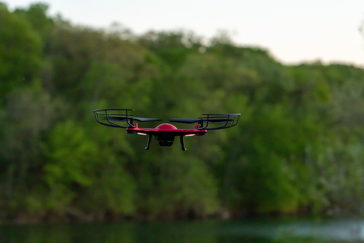
Drones, or unmanned aerial vehicles (UAVs), have emerged as a game-changer in environmental studies. Offering unparalleled flexibility and precision, drones can be deployed to collect data in hard-to-reach areas, providing researchers with real-time insights into ecosystems. Whether it’s surveying a forest after a wildfire or monitoring wildlife populations in remote habitats, drones are proving to be indispensable tools.
Remote sensing technologies are critical for mapping biodiversity. Scientists can monitor species distribution, habitat changes, and ecosystem health through detailed satellite and aerial imagery. This capability is essential for identifying areas of high biodiversity value and prioritizing conservation efforts. For instance, by analyzing drone imagery, researchers can pinpoint critical habitats that are under threat and develop targeted strategies to protect them.
Innovative habitat assessment techniques using remote sensing help identify critical habitats, track changes over time, and inform conservation strategies that protect endangered species and ecosystems. By employing advanced algorithms and machine learning, researchers can analyze vast datasets to detect subtle changes in habitat quality that may not be apparent through traditional survey methods. This proactive approach to habitat management is crucial in an era where many species are facing unprecedented threats.
Remote sensing enables the tracking of species movements and behaviors, providing valuable insights into migration patterns, breeding grounds, and the impact of climate change on wildlife. For instance, satellite tags can provide real-time data on animal movements, allowing researchers to study how species adapt to changing environments. This information is vital for developing effective conservation strategies and ensuring the survival of vulnerable species.
Remote sensing tools facilitate the analysis of climate change impacts by monitoring temperature variations, sea-level rise, and land-use changes. By integrating remote sensing data with climate models, scientists can develop more accurate predictions of future environmental conditions. This information is essential for policymakers and stakeholders as they work to develop mitigation strategies that address the challenges posed by climate change.
The integration of remote sensing data with ground-based observations enhances environmental analysis, allowing for more accurate predictions and assessments of ecological trends and phenomena. This holistic approach to data collection enables researchers to create comprehensive models that reflect the complexities of natural systems.
Machine learning algorithms are increasingly applied to remote sensing data, enabling automated analysis and pattern recognition that improve the accuracy of environmental assessments and predictions. By training algorithms on large datasets, researchers can identify trends and anomalies that might be overlooked by traditional analysis methods. This shift towards automation not only saves time but also enhances the precision of environmental monitoring efforts.
Advanced visualization techniques transform complex remote sensing data into accessible formats, helping stakeholders understand environmental changes and make informed decisions based on clear, visual representations. Interactive maps and 3D models allow users to explore data in ways that were not possible before, making it easier to communicate findings to a broader audience.
- What is remote sensing?
Remote sensing is the collection of data about the Earth's surface from a distance, typically using satellites or drones. - How does remote sensing help in environmental studies?
It allows researchers to monitor changes in ecosystems, track biodiversity, and analyze the impacts of climate change without needing to be on-site. - What are some applications of drone technology in environmental monitoring?
Drones are used for surveying habitats, tracking wildlife, and assessing damage from natural disasters. - How is machine learning used in remote sensing?
Machine learning algorithms analyze large datasets to identify patterns and improve the accuracy of environmental assessments.

Advancements in Satellite Technology
Recent developments in satellite technology have revolutionized the way we monitor and understand our environment. Gone are the days when we relied solely on ground surveys and limited aerial photography. Today, satellites equipped with advanced sensors are orbiting the Earth, capturing high-resolution imagery that provides invaluable insights into ecological changes and natural resource management. This leap in technology has not only enhanced data collection but has also made it possible to analyze vast areas of land with unprecedented detail.
One of the most exciting aspects of these advancements is the ability to obtain real-time data. Satellites can now transmit information back to Earth almost instantaneously, allowing researchers to track changes as they happen. For instance, if a forest fire erupts, satellites can quickly assess the extent of the damage, helping emergency services respond more effectively. This capability is crucial for managing natural disasters and mitigating their impacts on both human and ecological systems.
Moreover, advancements in multi-spectral and hyperspectral imaging have opened new doors for environmental studies. These imaging technologies allow scientists to capture data across various wavelengths of light, revealing information that is invisible to the naked eye. This means we can now detect changes in vegetation health, monitor water quality, and even identify mineral compositions from space. The ability to analyze these different spectra enables a more comprehensive understanding of environmental conditions.
To illustrate the impact of these advancements, consider the following table that summarizes key satellite missions and their contributions to environmental monitoring:
| Satellite Mission | Launch Year | Key Contributions |
|---|---|---|
| MODIS (Terra and Aqua) | 1999, 2002 | Global monitoring of land cover, temperature, and vegetation. |
| Sentinel-2 | 2015 | High-resolution imaging for land monitoring and disaster response. |
| Landsat 8 | 2013 | Long-term data for land use change and urban growth analysis. |
Furthermore, the integration of artificial intelligence (AI) with satellite technology is paving the way for even more advanced applications. AI algorithms can process and analyze satellite data much faster than traditional methods, identifying patterns and trends that might go unnoticed. This synergy between AI and satellite technology enhances our ability to make informed decisions about environmental management, conservation efforts, and sustainable practices.
In conclusion, the advancements in satellite technology are not just about capturing images from space; they represent a fundamental shift in how we gather and utilize environmental data. With improved resolution, real-time capabilities, and the integration of AI, we are better equipped than ever to tackle the pressing environmental challenges of our time. The future looks bright, and as these technologies continue to evolve, so too will our understanding of the delicate balance that sustains life on Earth.
Drone Applications in Environmental Monitoring
Drones have emerged as a game-changer in the field of environmental monitoring, providing researchers and conservationists with an innovative tool that combines flexibility, precision, and cost-effectiveness. Imagine being able to soar above a dense forest or a sprawling wetland, capturing high-resolution images and data that were once only accessible through labor-intensive methods or expensive aircraft. With drones, this is no longer a dream but a reality!
One of the most significant advantages of using drones in environmental studies is their ability to access hard-to-reach areas. Whether it’s a remote mountain range or a fragile coastal ecosystem, drones can easily navigate these challenging terrains, allowing scientists to gather crucial data without disturbing the environment. This capability is particularly important when studying sensitive habitats or endangered species, where human presence can have detrimental effects.
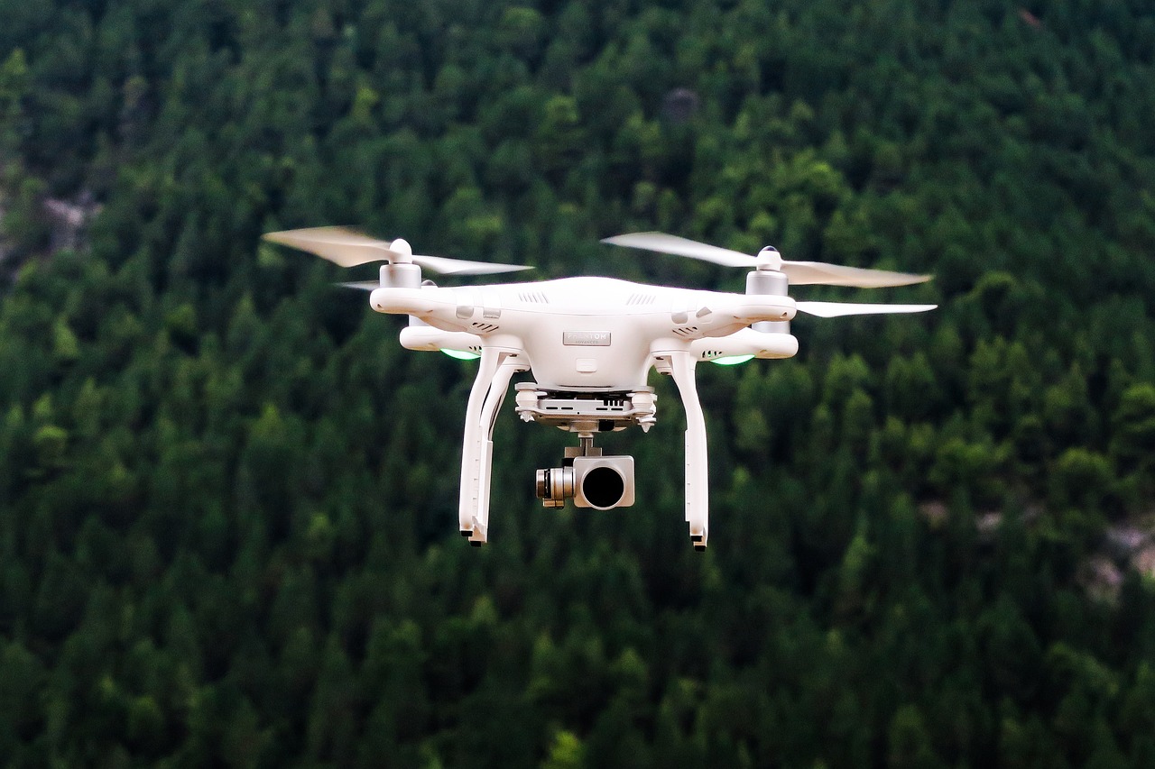
Moreover, drones are equipped with advanced sensors that can collect a variety of data types, including multispectral and thermal imagery. These sensors enable researchers to monitor plant health, track water quality, and assess land use changes over time. For example, multispectral imaging can reveal the health of vegetation by capturing wavelengths of light that are not visible to the naked eye, providing insights into stress levels and overall ecosystem health. This information is invaluable for effective resource management and conservation efforts.
Another exciting application of drones in environmental monitoring is their role in mapping biodiversity. By utilizing aerial imagery, researchers can create detailed maps that show species distribution and habitat changes. This is particularly useful in tracking the impacts of climate change on various ecosystems. For instance, a study might reveal how rising temperatures are shifting the ranges of certain species, prompting conservationists to adjust their strategies accordingly.
In addition to mapping biodiversity, drones facilitate habitat assessment techniques that are essential for identifying critical habitats and tracking changes over time. Using drones, scientists can monitor the health of ecosystems, assess the impacts of human activity, and develop targeted conservation strategies. This proactive approach helps to ensure that endangered species and their habitats receive the protection they need.
Furthermore, drones are instrumental in species tracking and monitoring. They can be deployed to follow the movements of wildlife, providing insights into migration patterns, breeding grounds, and behaviors that are often difficult to observe from the ground. For example, researchers can track the flight paths of birds or monitor the movements of marine mammals, gaining a deeper understanding of their needs and the challenges they face in a changing environment.
As technology continues to evolve, the applications of drones in environmental monitoring will undoubtedly expand, offering even more innovative solutions for researchers and conservationists. With their ability to collect real-time data and provide comprehensive insights into complex ecological systems, drones are paving the way for more effective and sustainable environmental management practices.
- What types of drones are used in environmental monitoring?
Drones used in environmental monitoring typically include quadcopters and fixed-wing models, equipped with various sensors for data collection, such as cameras, LiDAR, and multispectral sensors. - How do drones improve data accuracy in environmental studies?
Drones can capture high-resolution images and data from multiple angles, providing a more comprehensive view of ecosystems compared to traditional methods, which often rely on limited ground observations. - Are there any limitations to using drones for environmental monitoring?
Yes, limitations include battery life, weather conditions, and regulations regarding airspace. Additionally, drones may not be suitable for monitoring certain large-scale phenomena.
Mapping Biodiversity
Biodiversity is the lifeblood of our planet, encompassing the variety of life forms, ecosystems, and genetic diversity that sustain our environment. In recent years, remote sensing technologies have emerged as powerful tools for mapping biodiversity, allowing scientists to monitor and analyze the distribution of species, habitat changes, and overall ecosystem health with unprecedented precision. By utilizing high-resolution satellite imagery and aerial data, researchers can now gain insights into areas that were previously difficult to access, enabling a more comprehensive understanding of our natural world.
One of the key advantages of remote sensing in biodiversity mapping is its ability to cover vast areas quickly and efficiently. Traditional field surveys can be time-consuming and labor-intensive, often limiting the scope of research. In contrast, remote sensing allows for the collection of large datasets over extensive geographic regions, providing a broader perspective on biodiversity patterns. For instance, scientists can track changes in land cover and habitat fragmentation, which are critical for understanding the impacts of human activities on wildlife.
Moreover, remote sensing technologies facilitate a more detailed analysis of species distribution. By employing techniques such as spectral analysis, researchers can identify specific vegetation types and their associated fauna. This is particularly important for monitoring endangered species, as it helps to pinpoint critical habitats that need protection. For example, using satellite data, scientists can observe the health of coral reefs, which are vital ecosystems that support a diverse range of marine life. Such insights are invaluable for conservation efforts, enabling targeted actions to safeguard these fragile environments.
To illustrate the impact of remote sensing on biodiversity mapping, consider the following table that summarizes various remote sensing techniques and their applications:
| Remote Sensing Technique | Application |
|---|---|
| Satellite Imagery | Monitoring land cover changes and habitat loss |
| Lidar (Light Detection and Ranging) | Mapping forest structure and canopy height |
| Multispectral Imaging | Identifying vegetation types and health |
| Drone Surveys | Collecting high-resolution data in hard-to-reach areas |
In addition to mapping species distribution, remote sensing also plays a crucial role in assessing ecosystem health. By analyzing changes in vegetation cover, soil moisture, and temperature variations, scientists can gauge the overall vitality of an ecosystem. This is essential for understanding how ecosystems respond to environmental stressors such as climate change, pollution, and habitat destruction. With this knowledge, policymakers and conservationists can make informed decisions to protect and restore biodiversity.
In conclusion, the integration of remote sensing technologies into biodiversity mapping represents a significant leap forward in environmental research. As we continue to face challenges related to biodiversity loss and ecosystem degradation, these innovative tools provide us with the means to monitor and manage our natural resources more effectively. With the power of remote sensing, we can not only map the rich tapestry of life on Earth but also take action to preserve it for future generations.
- What is remote sensing? Remote sensing refers to the collection of data about an object or area from a distance, typically using satellites or aircraft.
- How does remote sensing benefit biodiversity mapping? It allows for the rapid collection of large datasets over vast areas, enabling detailed monitoring of species distribution and habitat changes.
- Can remote sensing replace traditional field surveys? While remote sensing provides valuable data, it complements rather than replaces traditional surveys, which are essential for ground-truthing findings.
- What are some challenges of using remote sensing in biodiversity studies? Challenges include data interpretation, the need for advanced technology, and ensuring that data is current and accurate.

Habitat Assessment Techniques
When it comes to , the integration of remote sensing technologies has truly transformed the way we evaluate and protect our ecosystems. Imagine being able to analyze vast stretches of land without ever stepping foot on them! This is the power of modern remote sensing. By utilizing high-resolution satellite imagery and aerial data, researchers can effectively identify and monitor critical habitats, track changes over time, and implement conservation strategies that are vital for protecting endangered species.
One of the most remarkable aspects of these techniques is their ability to provide a comprehensive view of habitat health. For instance, using multispectral imaging, scientists can assess vegetation health by analyzing different wavelengths of light reflected from plants. This allows them to determine not only the health of the vegetation but also its biodiversity. Such insights are crucial, as they help inform conservation efforts and land management decisions.
Moreover, advanced habitat assessment techniques often employ geospatial analysis. This involves layering various data sets to visualize changes in habitat over time. For example, researchers can overlay satellite imagery from different years to see how urban development, agricultural expansion, or natural disasters have affected specific habitats. The ability to visualize these changes is not just fascinating; it’s essential for understanding the long-term impacts on wildlife and ecosystems.
Here’s a quick look at some of the key techniques used in habitat assessment:
- Remote Sensing Surveys: These surveys provide data on land cover and vegetation types, which are crucial for habitat mapping.
- LiDAR (Light Detection and Ranging): This technology uses laser pulses to create detailed 3D models of the terrain, revealing hidden features like forest structure and canopy height.
- Ecological Modeling: Combining remote sensing data with ecological models helps predict how habitats will respond to various environmental changes, including climate change.
In summary, the advancements in habitat assessment techniques through remote sensing are not just about collecting data; they are about making informed decisions that can lead to sustainable management of our natural resources. The ability to monitor and analyze habitats from afar opens up new avenues for conservationists and researchers alike, allowing them to protect the biodiversity that is so essential for our planet's health.
Q: What is remote sensing?
A: Remote sensing is the process of collecting data about an object or area from a distance, typically using satellites or aerial technologies.
Q: How does remote sensing help in habitat assessment?
A: It allows researchers to gather high-resolution images and data over large areas, enabling them to monitor changes in habitats, assess vegetation health, and track wildlife.
Q: What are some common applications of remote sensing in environmental studies?
A: Common applications include mapping biodiversity, analyzing habitat changes, monitoring climate change impacts, and assessing land-use changes.
Q: Can remote sensing replace ground surveys?
A: While remote sensing provides valuable data, it often complements ground surveys rather than replacing them, as ground truthing is essential for accurate assessments.

Species Tracking and Monitoring
In the realm of environmental research, have emerged as critical components for understanding wildlife dynamics and ecosystem health. With the advent of remote sensing technologies, researchers can now observe and analyze animal movements in ways that were previously unimaginable. Imagine being able to monitor the migration patterns of a flock of birds or the territorial behaviors of a pack of wolves without disturbing their natural habitats. This is the power of modern remote sensing!
Remote sensing tools, such as satellite imagery and drone technology, provide invaluable data that help scientists track species across vast landscapes. These technologies enable the collection of high-resolution images and real-time data, which can be analyzed to reveal intricate details about animal behaviors and habitat usage. For example, researchers can use satellite data to examine how climate change impacts migration routes, allowing them to predict future movements and adapt conservation strategies accordingly.
Moreover, species tracking through remote sensing isn't just about observing animals; it also involves understanding the interconnectedness of ecosystems. By analyzing the movement patterns of different species, researchers can identify critical habitats and the factors that influence animal behavior. This holistic approach is essential for developing effective conservation plans that protect not only individual species but also the broader ecological networks they inhabit.
One of the most exciting advancements in this field is the integration of machine learning algorithms with remote sensing data. These algorithms can process vast amounts of information quickly, identifying patterns and trends that might be missed by human eyes. For instance, machine learning can help predict how changes in land use or climate might affect species distributions, enabling proactive measures to safeguard vulnerable populations.
Furthermore, the use of GPS collars and other tracking devices has revolutionized the way we monitor wildlife. These devices collect data on animal movements, which is then combined with remote sensing data to create comprehensive models of species behavior. The result is a clearer picture of how animals interact with their environments, which is crucial for effective wildlife management and conservation efforts.
In summary, remote sensing technologies have transformed the landscape of species tracking and monitoring. By providing detailed insights into animal movements and behaviors, these innovations empower researchers and conservationists to make informed decisions that enhance biodiversity and protect our planet's ecosystems. As we continue to harness the power of technology in environmental studies, the potential for discovering new species and understanding existing ones only grows—much like the intricate web of life that connects us all.
- What is remote sensing? Remote sensing is the process of obtaining information about an object or area from a distance, typically using satellite or aerial imagery.
- How does species tracking work? Species tracking involves using technology such as GPS collars and remote sensing data to monitor the movements and behaviors of animals in their natural habitats.
- Why is species monitoring important? Monitoring species is crucial for understanding ecological dynamics, informing conservation strategies, and protecting biodiversity.
- What role does machine learning play in remote sensing? Machine learning algorithms analyze large datasets to identify patterns and trends, enhancing the accuracy of environmental assessments and predictions.
Climate Change Impact Analysis
As we dive deeper into the implications of climate change, the role of remote sensing becomes increasingly vital. These advanced technologies empower researchers to monitor and analyze various environmental parameters that are affected by climate fluctuations. For instance, remote sensing tools can track temperature variations across different regions, providing crucial insights into how climate change is altering our planet's ecosystems. Imagine being able to visualize the gradual warming of a once-frigid area – it's like watching a slow-motion film of our world changing right before our eyes.
One of the most significant contributions of remote sensing to climate change impact analysis is its ability to monitor sea-level rise. This phenomenon poses a severe threat to coastal communities and ecosystems, and remote sensing technologies allow for precise measurements of sea-level changes over time. By analyzing satellite data, researchers can create detailed models that predict future sea-level scenarios, helping policymakers and communities prepare for potential flooding and erosion. This is akin to having a crystal ball that reveals the future of our coastlines, enabling proactive rather than reactive strategies.
Furthermore, remote sensing aids in assessing land-use changes, which are often exacerbated by climate change. As temperatures rise and weather patterns shift, land use can drastically change, leading to deforestation, urban sprawl, and habitat loss. By utilizing satellite imagery, scientists can observe these changes in real-time, providing a comprehensive view of how human activity intersects with environmental shifts. This information is critical for developing sustainable practices that mitigate the adverse effects of climate change.
To illustrate the impact of climate change visually, consider the following table, which summarizes key indicators monitored through remote sensing:
| Indicator | Description | Remote Sensing Application |
|---|---|---|
| Temperature Variations | Tracking changes in surface temperature across regions. | Satellite thermal imaging. |
| Sea-Level Rise | Monitoring the gradual increase in sea levels. | Satellite altimetry. |
| Land-Use Changes | Assessing shifts in land use due to urbanization or deforestation. | Aerial and satellite imagery analysis. |
The integration of these data points allows scientists to create comprehensive models that predict future climate scenarios. By understanding how various factors interrelate, we can develop more effective strategies for climate adaptation and mitigation. It's like piecing together a puzzle where each piece represents a different aspect of our environment, ultimately revealing a clearer picture of the challenges we face.
In conclusion, the impact analysis of climate change through remote sensing not only enhances our understanding of ecological changes but also equips us with the necessary tools to respond to these challenges. By leveraging technology, we can better prepare for the future and work towards a sustainable world. So, the next time you hear about remote sensing, remember that it’s not just about satellites in the sky; it’s about safeguarding our planet for generations to come.
- What is remote sensing? Remote sensing is the acquisition of information about an object or phenomenon without making physical contact, often using satellite or aerial imagery.
- How does remote sensing help in climate change analysis? It allows for the monitoring of environmental parameters like temperature, sea levels, and land use changes, providing crucial data for understanding climate impacts.
- Can remote sensing predict future climate scenarios? Yes, by analyzing historical data and current trends, remote sensing can help model and predict future climate scenarios.

Data Integration and Analysis
In the realm of environmental studies, the integration of remote sensing data with ground-based observations has emerged as a game-changer. This synergy not only enhances the reliability of data but also enables researchers to make informed decisions that can significantly impact conservation efforts and resource management. Imagine trying to solve a complex puzzle; each piece represents different types of data, and when they fit together, they reveal a clearer picture of our environment. This is precisely what data integration achieves.
By combining satellite imagery with terrestrial data, scientists can develop a comprehensive understanding of ecological trends. For instance, a study might utilize satellite data to assess land use changes over time, while ground observations provide insights into soil health and plant diversity. This multifaceted approach allows for a more nuanced analysis of environmental conditions, leading to better predictive models and more effective management strategies.
One of the most exciting advancements in this area is the use of machine learning algorithms. These algorithms can process vast amounts of data at lightning speed, identifying patterns and correlations that would be nearly impossible for humans to detect. For example, researchers can analyze satellite images to track deforestation rates while simultaneously assessing the impact on local wildlife populations through ground data. This kind of analysis not only enhances our understanding of ecological dynamics but also informs policy-making and conservation efforts.
Moreover, the visualization of integrated data plays a crucial role in communicating findings to stakeholders. Advanced visualization techniques transform complex datasets into intuitive formats, making it easier for decision-makers to grasp the implications of environmental changes. For instance, interactive maps can illustrate changes in land cover over time, allowing stakeholders to see the direct impact of human activities on ecosystems. This clarity is essential for fostering collaboration among scientists, policymakers, and the public.
To illustrate the effectiveness of data integration, consider the following table that highlights the benefits of combining remote sensing data with ground-based observations:
| Data Type | Benefits |
|---|---|
| Remote Sensing Data | Provides broad spatial coverage, real-time monitoring, and high-resolution imagery. |
| Ground-Based Observations | Offers detailed, localized insights into ecological conditions and species behaviors. |
| Integrated Data | Combines the strengths of both data types, leading to more accurate assessments and predictions. |
In conclusion, the integration of remote sensing data with ground-based observations is not just a technical advancement; it's a crucial step towards achieving sustainable environmental management. By harnessing the power of technology and data, we can better understand our planet's complexities and work towards solutions that protect our natural resources for future generations. The future of environmental studies is bright, and data integration is at the forefront of this evolution.
- What is remote sensing? Remote sensing is the process of collecting data about an object or area from a distance, typically using satellites or drones.
- How does data integration improve environmental studies? Data integration combines different data sources, enhancing the accuracy and depth of environmental analysis.
- What role does machine learning play in remote sensing? Machine learning algorithms automate data analysis, identifying patterns and trends that aid in environmental assessments.
- Why is visualization important in environmental data analysis? Visualization helps stakeholders understand complex data, facilitating informed decision-making and effective communication.

Machine Learning in Remote Sensing
Machine learning is rapidly transforming the landscape of remote sensing, making it a powerful ally in the quest for environmental insights. Imagine having a tool that not only collects vast amounts of data but also learns from it, improving its accuracy over time. That's exactly what machine learning does! By harnessing algorithms that can analyze complex datasets, researchers can uncover hidden patterns and trends that were previously difficult to detect.
One of the most exciting aspects of integrating machine learning with remote sensing is its ability to automate the analysis process. Traditional methods often required extensive manual interpretation, which was not only time-consuming but also prone to human error. Now, with machine learning, we can train models to recognize specific features in satellite images or aerial data. For instance, these models can differentiate between various land cover types, such as forests, wetlands, and urban areas, with remarkable precision.
Furthermore, the application of machine learning extends beyond simple classification tasks. It can also predict future environmental changes based on historical data. For example, by analyzing patterns of deforestation over the years, machine learning algorithms can forecast which areas are at the highest risk of losing biodiversity. This predictive capability is invaluable for conservationists and policymakers who need to make informed decisions about resource management.
To illustrate the impact of machine learning in remote sensing, consider the following table that highlights some key applications:
| Application | Description | Benefits |
|---|---|---|
| Land Cover Classification | Identifying different types of land use from satellite imagery. | Improved accuracy and efficiency in mapping land cover changes. |
| Change Detection | Monitoring changes in landscapes over time. | Early warning for environmental degradation and urban expansion. |
| Species Habitat Modeling | Predicting suitable habitats for various species based on environmental factors. | Supports conservation efforts by identifying critical habitats. |
Moreover, machine learning algorithms can process vast datasets at speeds that humans simply can't match. This capability allows researchers to analyze real-time data from various sources, such as satellite imagery, weather stations, and even social media feeds related to environmental events. By integrating these diverse data streams, machine learning helps create a more comprehensive picture of ecological changes.
Yet, it's essential to remember that while machine learning offers incredible potential, it also requires a solid foundation of quality data. Garbage in, garbage out, as the saying goes. Therefore, ensuring that the data fed into these algorithms is accurate and representative is crucial for achieving reliable results. Collaboration between data scientists, ecologists, and remote sensing experts is vital to maximize the benefits of this technology.
In conclusion, the fusion of machine learning and remote sensing is paving the way for innovative solutions in environmental studies. As we continue to refine these technologies, we can look forward to a future where data-driven insights lead to more effective conservation strategies and sustainable management practices. The journey is just beginning, and the possibilities are as vast as the landscapes we seek to protect.
- What is machine learning in remote sensing?
Machine learning in remote sensing refers to the use of algorithms that learn from data to automate the analysis and interpretation of remote sensing information, enabling more accurate insights into environmental changes.
- How does machine learning improve data analysis?
By recognizing patterns and making predictions based on historical data, machine learning enhances the speed and accuracy of data analysis in remote sensing applications.
- What are the challenges of using machine learning in remote sensing?
Challenges include the need for high-quality data, the complexity of model training, and the necessity of interdisciplinary collaboration to ensure effective interpretation of results.

Visualization Techniques
In the realm of remote sensing, the ability to visualize data effectively is nothing short of revolutionary. Imagine standing on a mountaintop, gazing down at a vibrant tapestry of colors that represents the health of an entire ecosystem. Visualization techniques transform complex datasets into understandable and actionable information, allowing researchers and decision-makers to see the bigger picture. These techniques play a crucial role in environmental studies, where intricate data sets can often feel overwhelming and abstract.
One of the most effective ways to visualize remote sensing data is through geographic information systems (GIS). GIS platforms allow users to layer various data types—such as satellite imagery, topographical maps, and climate data—over one another. This layered approach provides a comprehensive view of environmental changes over time, enabling scientists to identify trends and correlations that would be difficult to discern from raw data alone. For instance, a GIS analysis might reveal how deforestation in one area correlates with increased flooding in another, thereby highlighting the interconnectedness of ecological systems.
Moreover, advanced visualization techniques, like 3D modeling and interactive mapping, have emerged as powerful tools in environmental research. 3D models can depict terrain and vegetation in a way that is much more intuitive than flat images. This is particularly useful for urban planners and conservationists who need to understand how changes in land use can affect local ecosystems. Interactive maps allow users to engage with the data, zooming in on specific areas, adjusting parameters, and even simulating future scenarios based on different environmental policies.
Another exciting development in visualization is the use of data dashboards. These dashboards aggregate various data sources and present them in real-time, giving stakeholders immediate access to the information they need to make informed decisions. For example, a dashboard might display real-time air quality data alongside satellite imagery of pollution sources, allowing city officials to respond swiftly to environmental hazards.
To illustrate some of these techniques, consider the following table that outlines different visualization methods and their applications in environmental studies:
| Visualization Technique | Application |
|---|---|
| GIS Mapping | Layering data to analyze spatial relationships and trends. |
| 3D Modeling | Visualizing terrain and vegetation for better understanding of land use impacts. |
| Interactive Mapping | Engaging users in data exploration to understand complex scenarios. |
| Data Dashboards | Real-time data aggregation for immediate decision-making. |
In summary, visualization techniques in remote sensing are not just about making data pretty; they are about enhancing understanding and facilitating action. By transforming complex datasets into visual formats, these techniques empower researchers, policymakers, and the public to engage with environmental issues more effectively. As technology continues to advance, we can expect even more innovative visualization methods that will further bridge the gap between data and decision-making, ultimately leading to more sustainable environmental practices.
- What are visualization techniques in remote sensing? Visualization techniques in remote sensing refer to methods that transform complex data into understandable visual formats, such as maps, models, and dashboards.
- How does GIS enhance environmental studies? GIS enhances environmental studies by allowing researchers to layer various data types, making it easier to analyze spatial relationships and identify trends.
- What is the importance of 3D modeling? 3D modeling provides a more intuitive understanding of terrain and vegetation, which is crucial for urban planning and conservation efforts.
- What role do data dashboards play? Data dashboards aggregate real-time data, providing stakeholders with immediate access to critical information for informed decision-making.
Frequently Asked Questions
- What is remote sensing?
Remote sensing is the process of collecting data about an object or area from a distance, typically using satellites, drones, or aircraft. This technology allows scientists to gather information about the Earth's surface without being in direct contact, making it invaluable for environmental studies.
- How has satellite technology improved environmental monitoring?
Advancements in satellite technology have led to high-resolution imagery and more accurate data collection. These improvements enable researchers to track ecological changes, monitor natural resources, and respond effectively to environmental challenges.
- What role do drones play in environmental studies?
Drones provide flexibility and precision in data collection, allowing researchers to access hard-to-reach areas. They can gather real-time information on ecosystems, making them a powerful tool for environmental monitoring and research.
- How does remote sensing help in mapping biodiversity?
Remote sensing technologies allow scientists to monitor species distribution and habitat changes through detailed satellite and aerial imagery. This information is crucial for assessing ecosystem health and implementing conservation strategies.
- What are habitat assessment techniques in remote sensing?
Innovative habitat assessment techniques utilize remote sensing to identify critical habitats and track changes over time. These methods inform conservation strategies aimed at protecting endangered species and their ecosystems.
- Can remote sensing track species movements?
Yes, remote sensing enables the tracking of species movements and behaviors. This data provides valuable insights into migration patterns, breeding grounds, and the impacts of climate change on wildlife.
- How does remote sensing analyze climate change impacts?
Remote sensing tools monitor temperature variations, sea-level rise, and land-use changes, which are essential for analyzing climate change impacts. This information aids in developing effective mitigation strategies.
- What is the significance of data integration in environmental analysis?
Integrating remote sensing data with ground-based observations enhances the accuracy of environmental assessments. This holistic approach allows for better predictions and a deeper understanding of ecological trends.
- How is machine learning used in remote sensing?
Machine learning algorithms are applied to remote sensing data for automated analysis and pattern recognition. This technology improves the accuracy of environmental assessments and predictions, making it easier to understand complex ecological phenomena.
- What are advanced visualization techniques in remote sensing?
Advanced visualization techniques transform complex remote sensing data into accessible formats. These visual representations help stakeholders understand environmental changes and make informed decisions based on clear and concise information.